Noertrange Airfield

ELNT · Wiltz, Luxembourg

About Noertrange Airfield

ICAO ELNT
FIR Bruxelles FIR
Region Wiltz
Country Luxembourg
Runways 8/26
Type Small airport
Coordinates (ARP) 49.9811, 5.91778   495852N 0055504E
Coordinates (Center) 49.98094, 5.91816   495851N 0055505E
Variation 2.8° E (2024)
Timezone Luxembourg (+2 h)
Local time May 7, 2024 08:28

Runways

ID True Heading Magnetic Heading Length Width Surface Latitude Longitude
8 075° 072° 657 m 30 m Grass 49.9817 5.9226
26 255° 252° 49.9802 5.9137

Do not use for flight planning
The airport may be closed or require prior permission. True headings and the coordinates of runway ends may be an estimation. Magnetic headings are calculated from true headings using the WMM 2020 model.

Noertrange Airfield

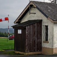
Noertrange Airfield is a small airport in Wiltz, Luxembourg. The airport is located at latitude 49.98094 and longitude 5.91816. The airport has one runway: 8/26. The ICAO airport code of this field is ELNT. Nearby other airfields are Utscheid Segelflugplatz, Saint Hubert Air Base, Arlon-Sterpenich ULM Airfield, Saint Hubert Airfield and UL-Fluglatz Ernzen.

Noertrange Airfield does not publish a METAR, the nearest weather station is Luxembourg-Findel International Airport, which is 45 km away. The flight information region (FIR) is Bruxelles.

Noertrange Airfield is in the timezone of Europe/Luxembourg. Difference with UTC is +2 h. Today the sun rises at 06:01 and sets at 21:04. This applies to Noertrange Airfield, the universal daylight period may be different. The difference between the local time and UTC is +2 hour. Daylight saving time is currently in progress.

Things to do at this airport

Go to Vliegles.nl to find flying lessons, skydives and other flying experiences. Browse the page for all available activities near Noertrange Airfield. You can also use the search function to find specific flying lessons, skydives or other flying experiences near your place.

On this airport you can find skydive centers. The only known company on this field is Airfield de Noertrange.
Companies

Skydive centers

Add company

References

Nearby airports

Airport ID Distance Direction
Ettelbruck ELET 19 km 138°
Useldange Glider Field ELUS 24 km 171°
Utscheid Segelflugplatz DE-0038 30 km 086°
Saint Hubert Air Base EBSU 35 km 279°
Lierneux / Centre Hospitalier Spécial l'Accueil Heliport EPLX 35 km 344°
Lierneux / Centre Hospitalier EBLX 35 km 344°
Arlon-Sterpenich ULM Airfield EBAR 36 km 183°
Saint Hubert Airfield EBSH 37 km 279°
Bra heliport EBMS 40 km 340°

Navigational aids

Name Ident Type Distance Direction
Diekirch DIK VOR-DME 20 km 131°
Report a change