Lille/Marcq-en-Baroeul Airfield

LFQO · North, Hauts-de-France, France

About Lille/Marcq-en-Baroeul Airfield

ICAO LFQO
FIR Paris FIR
Region Hauts-de-France
Country France
Runways 7/25
Type Small airport
Coordinates (ARP) 50.6872, 3.07556   504114N 0030432E
Coordinates (Center) 50.68817, 3.07467   504117N 0030429E
Variation 2.0° E (2024)
Timezone Paris (+2 h)
Local time May 4, 2024 12:08

Lille/Marcq-en-Baroeul Airfield

Lille/Marcq-en-Baroeul Airfield is a small airport in North, Hauts-de-France, France. The airport is located at latitude 50.68817 and longitude 3.07467. The airport has 2 runways: 17/35 and 7/25. The ICAO airport code of this field is LFQO. Nearby other airfields are Lille-Lesquin Airport, Wevelgem Airport, Moorsele Airfield, Amougies Airfield and Lens Benifontaine Airfield.

Lille/Marcq-en-Baroeul Airfield does not publish a METAR, the nearest weather station is Lille-Lesquin Airport, which is 14 km away. The flight information region (FIR) is Paris.

Lille/Marcq-en-Baroeul Airfield is in the timezone of Europe/Paris. Difference with UTC is +2 h. Today the sun rises at 06:15 and sets at 21:13. This applies to Lille/Marcq-en-Baroeul Airfield, the universal daylight period may be different. The difference between the local time and UTC is +2 hour. Daylight saving time is currently in progress.

Things to do at this airport

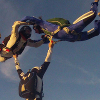
Go to Vliegles.nl to find flying lessons, skydives and other flying experiences. Browse the page for all available activities near Lille/Marcq-en-Baroeul Airfield. You can also use the search function to find specific flying lessons, skydives or other flying experiences near your place.

On this airport you can find flying clubs and skydive centers. Companies on this airport are A AIR O, Union Aérienne de Lille-Roubaix-Tourcoing and EFPLB - Ecole Francaise de Parachutisme de Lille Bondues.

Companies

Flying clubs

Skydive centers

Add company

References

Do not use for flight planning
The airport may be closed or require prior permission. True headings and the coordinates of runway ends may be an estimation. Magnetic headings are calculated from true headings using the WMM 2020 model.

Runways

ID True Heading Magnetic Heading Latitude Longitude Approx. length
17 172° 170° 50.686 3.0755 847 m
35 352° 350° 50.6935 3.0739
7 075° 073° 50.6876 3.0804 834 m
25 255° 253° 50.6856 3.069

Do not use for flight planning.
True headings and the coordinates of runway ends may be an estimation. Runway lengths are calculated as the distance between the coordinates of the runway ends. Magnetic headings are calculated from true headings using the WMM 2020 model.

Nearby airports

Airport ID Distance Direction
Centre Hospitalier Régional Heliport FR-0129 9.8 km 196°
Lille-Lesquin Airport LFQQ 14 km 173°
Zandvoorde Heliport EBZO 16 km 333°
Wevelgem Airport EBKT 17 km 032°
Warcoing heliport EBPW 18 km 077°
Kortrijk - AZ Groeninge Helipad EBKG 18 km 046°
Moorsele Airfield EBMO 19 km 015°
Herlies FR-0771 20 km 235°
Kuurne EBKU 23 km 033°

Navigational aids

Name Ident Type Distance Direction
Lesquin LEQ VOR-DME 14 km 175°
Kortrijk OKT NDB 18 km 034°
Report a change