Kamloops Airport

CYKA · British Columbia, Canada

About Kamloops Airport

ICAO CYKA
IATA YKA
FIR Vancouver FIR
Region British Columbia
Country Canada
Runways 4/22
Type Midsized airport
Coordinates (ARP) 50.7022, -120.444   504208N 1202638W
Coordinates (Center) 50.70237, -120.44411   504209N 1202639W
Variation 15.5° E (2024)
Timezone Vancouver (-7 h)
Local time May 3, 2024 15:55

Runways

ID True Heading Magnetic Heading Length Width Surface Latitude Longitude
9 103° 087° 7,999 ft 148 ft Asphalt 50.7005 -120.4318
27 283° 267° 50.7055 -120.4654
4 061° 045° 2,073 ft 49 ft Asphalt 50.7031 -120.4357
22 241° 225° 50.7003 -120.4436

Do not use for flight planning
The airport may be closed or require prior permission. True headings and the coordinates of runway ends may be an estimation. Magnetic headings are calculated from true headings using the WMM 2020 model.

Kamloops Airport

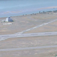
Kamloops Airport is a midsized airport in British Columbia, Canada. The airport is located at latitude 50.70237 and longitude -120.44411. The airport has 2 runways: 9/27 and 4/22. The ICAO airport code of this field is CYKA. The airport's IATA code is YKA. Nearby other airfields are Princeton Automatic Weather Reporting System, Knutsford Airfield, Kamloops Model Airplane Society Airstrip, Heffley Creek Airstrip and Tranquille Valley Airfield.

Kamloops Airport publishes a METAR. The flight information region (FIR) is Vancouver.

Kamloops Airport is in the timezone of America/Vancouver. Difference with UTC is -7 h. Today the sun rises at 05:30 and sets at 20:26. This applies to Kamloops Airport, the universal daylight period may be different. The difference between the local time and UTC is -7 hour. Daylight saving time is currently in progress.

Things to do at this airport

Go to Vliegles.nl to find flying lessons, skydives and other flying experiences. Browse the page for all available activities near Kamloops Airport. You can also use the search function to find specific flying lessons, skydives or other flying experiences near your place.

On this airport you can find flying schools and skydive centers. Companies on this airport are Vayu Aviation, Auroa Aviation, Kamloops Skydivers SPC and TylAir Aviation.

Companies

Flying schools

Skydive centers

Add company

References

Nearby airports

Airport ID Distance Direction
Kamloops CZKA 0.4 NM 109°
Kamloops Seaplane Base CAH7 0.4 NM 108°
Kamloops (Bc Hydro) Heliport CA-0906 3.5 NM 127°
Kamloops RCMP Helipad CA-0801 4.1 NM 133°
Kamloops (Royal Inland Hospital) Heliport CBC4 4.7 NM 115°
Princeton Automatic Weather Reporting System CWPR 6.7 NM 204°
Knutsford Airfield CA-0069 8.1 NM 140°
Kamloops Model Airplane Society Airstrip CA-0810 11 NM 038°
Heffley Creek Airstrip CKA2 12 NM 033°

Navigational aids

Name Ident Type Distance Direction
Kamloops XPP DME 0.6 NM 290°
Kamloops YKA NDB 4.3 NM 105°
Report a change